Scientists are unlocking the secrets of permafrost in several ground-breaking projects along the Inuvik-Tuktoyaktuk Highway.
Three permafrost researchers from the Aurora Research Institute explained their findings April 27.
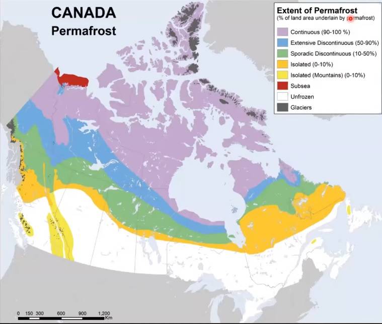
Permafrost is ground that remains frozen for two or more consecutive years. Almost half of Canada has a permafrost layer of some sort. With thousands of kilometres of infrastructure resting on top of it, melting permafrost is a major concern. As ice melts away, it leaves gaps that cause ground on top of it to collapse. This leads to all sorts of dangerous problems, including landslides, sinkholes and washouts.
To address these concerns, the GNWT established a permafrost research corridor along the ITH. Having only been constructed in 2017, the road provides a perfect opportunity to see how infrastructure affects permafrost.
“The development of the road has provided unprecedented access to this dynamic permafrost environment,” explained Ashley Rudy of the Northwest Territories Geological Survey. “Which has increased research interests and activities of scientists from across Canada and the world.
“So it’s created a really unique opportunity to capitalize on the legacy of research and scientific infrastructure. In turn the region has become a hub for applied permafrost research.”
Aside from establishing a baseline of research and monitoring high risk areas, the research corridor will also be used to test engineering techniques to determine their impacts. Researchers are also mapping out hazardous areas for public safety. Many permafrost landslides move in slow motion, slowly sliding downwards as ice melts away, exposing more ice which melts the following year.
Researchers are also working closely with the Inuvialuit Land Administration to share data and experience to help build professional capacity in the region. Workshops on environmental monitoring are run annually, the most recent on March 23.
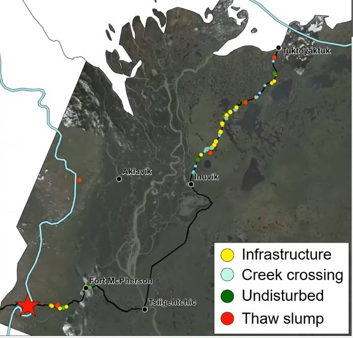
Long before the ITH was built, scientists were busy gathering data along its route. oreholes were drilled at key points, including streams, bridge crossings and embankments. After the gravel was laid, more boreholes were dug in undisturbed ground near the highway. In total, 100 sample points were dug. Each allows scientists to monitor ground temperature at multiple layers of the ground. All the data collected will eventually be available through the Northwest Territories permafrost database, which is currently in development.
“The goal will be to host all permafrost related data, both historic that we get our hands on and all future ground temperature and geotechnical data in one spot,” said Rudy. “We’re in the process right now of uploading that data to the database.”
Once the system is complete, anyone will be able to find permafrost information by way of a clickable map or searchable database.
Crushed rock and gravel
Significant observations are already coming out of the data.
Rudy noted that the addition of gravel to the ground the ITH sits on is having an effect on the nearby environment.
“Right off the bat we can see that there’s a really large swing in the temperature profiles of the embankments,” she said. “It gets really really warm in the summer and very very cold in the winter. This is a direct reflection of the properties of the embankment material.
“It’s crushed rock and gravel and dark in colour, so in the summertime it heats up really fast. In the winter time, because the roads are plowed, the cold winter temperatures have a direct impact on the road surface, causing it to get very very cold. If we look at the natural landscape… we have a much more dampened impact. In the winter we get snow which insulates the ground, buffering the impact of the cold winter air temperatures on the ground. In the summer we have vegetation, again causing a change in insulative properties.”
In three years of monitoring the ITH, the data so far shows a downward trend in average ground temperature.
Snow warming the ground
As it turns out, a blanket of snow is more than just a clever saying. Experiments by the ARI suggest a thick layer of snow actually helps the ground stay warm.
Different factors can affect ground temperatures. Thicker vegetation can reflect sunlight and shade the ground in the summer, keeping it cooler. Vegetation also traps more snow, making a thicker layer in the winter and trapping heat. As winter progresses and roads are plowed, snow also accumulates along the sides of the road.
“So all that heat that entered the system in the summer can’t as effectively escape in the winter,” explained ARI scientist Alice Wilson. “If that happens and you have increases in snow throughout time, what’s going to eventually occur is you’re going to have more heat trapped in the system,” which can result in thawing permafrost.
To test her hypothesis, Wilson’s team compared ground temperature from undisturbed sites to sites with snow packed down by heavy machinery, in areas with heavy and light snowfall.
Her findings indicate where there is a thick layer of snow, the compacted snow helps the ground lose heat. Wilson said she had one more year of research to finish the project, then she’s hoping to establish a working model to further understand the relationship.
Liquid streams at -30C
Another factor researchers are looking at is surface water. Scientists already know major rivers actually have bouts of liquid flow during the winter, even at extreme temperatures. Ph.D. candidate Tim Ensom showcased his work on streams crossing the ITH and how they affect permafrost.
“Streams that have winter flow can represent safety and management challenges for infrastructure like highways if flow lasts for long enough in the winter to freeze and block culverts,” he pointed out. “Trapping or impoundment of spring fresh water by blocked culverts can lead to an embankment scour or even wash out.”
Stream temperatures can be far more variable than larger bodies of water. Ensom showed data of sites sampled where the temperature of the water was consistently 0C over the winters of 2017 to 2019, then dropped well below freezing in the 2019-2020 winter. A control sample at a nearby hilltop had a consistently low temperature all three years.
He attributed this to a colder winter in much of the North that year, but noted the 0C streams indicate liquid water during at least part of the winter. Scientists have also observed evidence of liquid water at much colder temperatures, down to -30C.
Data also suggests forests and heavy vegetation may help regulate stream temperatures, keeping them more consistent. Larger streams are more likely to maintain liquid sections than smaller ones.
“Temperatures in a taiga environment…were only half a degree to one degree colder in the low snow year than their average,” he said. “Over the previous two years in a tundra average annual surface temperatures were 3.5 to 4.5 C colder in the low snow year than their average.
“Stream snow cover has been observed to be thinner in taiga forest than on tundra. This may occur because a thicker tree canopy covers streams in the forest. The forest may also block the wind so less snow is blown into taiga streams.”