With climate change threatening thousands of years of cultural heritage, the race is on to map Inuvialuit Ancestral Sites and either preserve or document them before they return to the sea.
Part of the Aurora Research Institute’s Virtual Speaker Series, the presentation was first broadcast over Zoom on Nov. 17 — International Global Information Satellite (GIS) Day — and has since been published on the ARI’s YouTube channel.
GNWT Cultural Places Program climate change archaeologist Dr. Mike O’Rourke explained the challenge of studying archaeology was exacerbated by the changes to the landscape brought on by climate change. Longer periods of low-ice cover expose the coastline to more ocean waves, which is causing it to rapidly erode, taking ancient Inuvialuit artifacts with them and the heritage of Inuit Nunangat — the name for the homelands of the Inuit.
“It’s important to consider this not as a mere change in terminology,” said O’Rourke. “But rather is a change in the way that we conceptualize the area overall in more humanistic terms.”
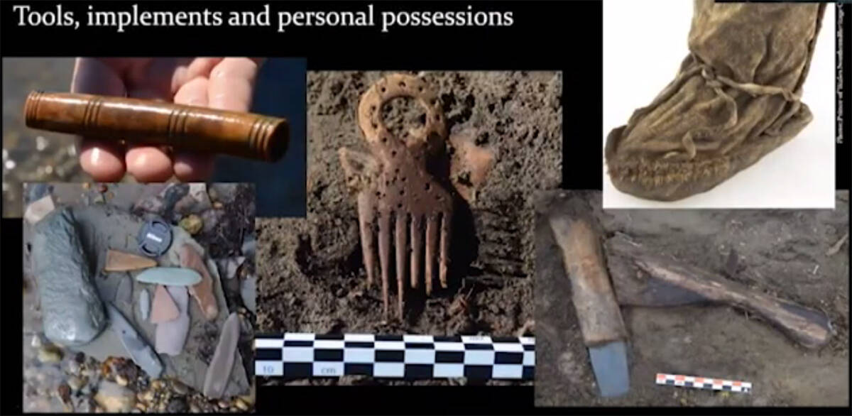
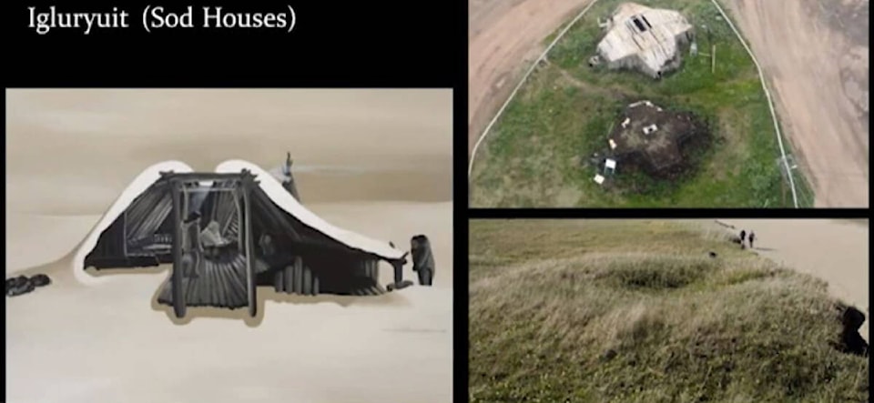
Traces of the ancestral way of life of the Inuvialuit and their ancestors are all over the landscape of the Beaufort Delta, often preserved in permafrost dating back to past ice ages, or to more recent developments such as Igluryuit, a type of sod house dug into the permafrost to use the ground as a cold trap, keeping warm air inside the structure and cold air out. Timber for the structure of the Igluryuit was sourced from driftwood coming down the Mackenzie River.
Other artifacts discovered include children’s kamek or boots, combs and brushes, containers for sewing needles, blades and other tools for living on the land. O’Rourke noted much of the recovered archaeological finds are found on beaches near eroding ancestral sites or are actively recovered from sites on the verge of eroding away completely.
Climate Change can impact ancestral sites in a number of ways. Longer warm seasons leads to more vegetation, which can push soils apart and undermine the foundation of structures. The abundance of heat also means more animal activity, particularly bears and sik sik (ground squirrels) — the latter which burrow holes through buried Igluryuit. Bear then dig bigger holes trying to get to the sik sik.
Melting permafrost both exposes items to the elements, which could cause them to erode or break down, and introduces them to biological agents like bacteria, oxygen and moisture, which can make many items decompose. It also can create ice spurs or huge slumps, damaging the foundation of structures. One slump, hundreds of metres in length, is believed to have wiped out the remains of an entire Inuvialuit village.
Longer summers also mean more storms, with increased frequency in lightning strikes, which could cause large fires on the dry tundra. But rising sea levels and coastal erosion are having the most dramatic impact.
Oftentimes the decision to excavate a site draws from the chances the site will be gone within a few years, noted O’Rourke. He added many areas along the coast are covered with artifacts already eroded out of the permafrost, but washed back on shore from the tide.
Effects on the landscape and archaeological sites is happening rapidly enough, but the scale of the landmass it’s occurring over is what really alarms scientists.
“It’s a slow process,” said O’Rourke. “But it does introduce bacteria oxygen water to those objects and it ultimately results in their rot. As slow as it is, it’s happening everywhere so this is really kind of a blanket impact that’s happening in the region.”
A sinking landscape
Canada has over 200,000 kilometres of shoreline, much of it along the Arctic Ocean. Different sections of shoreline are more susceptible to sea level rise than others, but the shoreline in the Inuvialuit Settlement Region is among the most sensitive to changes. This is because the landmass making up the ISR is actually sinking.
Being solid chunks of ice that span for kilometres and are just as thick, glaciers are extremely heavy. So heavy, in fact, they push the land underneath downward towards the mantle. The displacement pushes surround crust upwards. If the glaciers recede, as they have, the process is reversed and the landmass pushed down begins to rise and everything else begins to sink again.
What this means is the ISR — which was not covered by the last glaciation — is sinking at a rate of two millimetres per year, which is compounding concerns of rising sea levels on the Arctic coast. With sea levels expected to rise between one and 2.6 metres, O’Rourke said the sinking landmass of the ISR brings the total increase to close to three metres of sea level rise in Tuktoyaktuk — which would effectively wash the entire hamlet into the sea.
To address all these problems, O’Rourke is spearheading a community mapping project in the ISR. Community mapping allows both people to get a big-picture view of what is happening to the landscape, but also to communicate where important historical and cultural sites are in relation to that. They also can allow a community to paint out how they would like to see landmasses managed or used.
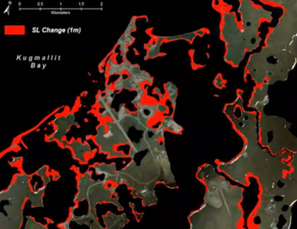
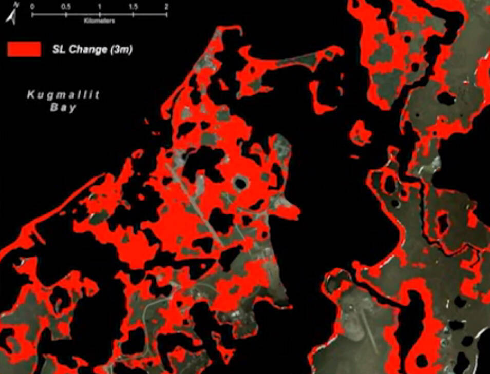
O’Rourke said the NWT Community Mapping project is relying on two techniques for the ISR. The first is using archival air photos and satellite imagery to construct a historical model of shoreline changes. With these models, researchers can then calculate the speed at which the shoreline is changing.
These models can also be cross-referenced with data from the Landsat Long-Term Change Detection system, a series of satellites which have been photographing the Earth since 1985. Using this, the NWT Centre for Geomatics has been able to map out a map of the territory from 1985 to 2019 and found the data matched up with the models quite effectively. O’Rourke added the Landsat data was freely available to anyone to view online.
“I really think it’s going to be invaluable in the community mapping process,” he said. “Allowing community members to highlight areas of cultural significance which they consider at risk based on the presence of changes nearby, allowing us to work together to establish targets for more focused management efforts.
“Where there are major changes taking place or even minor changes in areas that are considered culturally significant, we can use these results to justify the expense involved in conducting site visits — preferably with the very people who made those observations with us pouring over these maps.”