

NNSL file photo
The city of Yellowknife is currently receiving feedback from residents as they release their plans on how the city will develop over the next several years.
The city is mandated by the GNWT to come up with a new plan every 20 years, with appropriate updates every 8 years.
The newly drafted 107-page document details how the city sees each district in the city developing and will act as a map for future policy and decision making through setting goals for each district in Yellowknife.
Some of the more general goals set out in the plan include supporting the Yellowknives Dene First Nation's inherent right to land in Yellowknife and making no plans with land included in their interim land withdrawal until the Akaitcho process is complete.
The city also is making concessions on the environment and climate change action by increasing corporate shares in renewable energy use, incentivising sustainable modes of transportation, supporting remediation of mines and quarries, reducing use of fossil fuels and more.
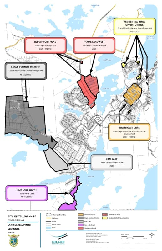
Kam Lake and industrial uses
The community plan has divided Kam Lake into a northern and southern sub-districts.
The Northern area, or just Kam Lake, will no longer support heavy industrial uses, but will allow for the continuation of "light industrial" uses.
Light industrial uses include warehouses, large commercial show rooms, outdoor storage, and agriculture activities. Any residential land use would be accessory to commercial operations.
There will also be no sites dedicated to accommodate tourist or tourism activities beyond "staging, storage and warehousing" for tourism operators.
All heavy industrial will now be moved to the Engle business district, just south of the airport.
Kam Lake South will be the are which will include accommodations for dog lots, lots where people can live with dogs and an increased focus on tourism services.
"The City recognizes the traditional and historical importance of dog sledding in the community and the access to trails and lakes that have been established because of a long-term tenure in this area of Yellowknife," stated the document.
The dog-lots have been an ongoing issue with the city for decades, which saw some resolution earlier this year when the city decided to sell the dog-lots to the Yellowknife Dog Trotters Association.
Kam Lake South will not be accommodating any further subdivision of land for residential uses. This will be the same story for Grace Lake, a district with its own plan but in a neighbouring area, which will see no further residential subdivision without the approval of council.
Con and Giant mines
The Con Mine site is currently being remediated but the city is looking forward to what will be done in the area once it is complete.
Residential will be a low priority as the city does not plan on furthering any developments until 65 per cent of all other existing land supply in the city is developed.
After remediation, however, the city will be looking to work with private land owners to acquire a parcel of land adjacent to the mine for "a sports park for field sports such as softball, fastball, and soccer if the level of remediation allows for."
The city will also be looking to preserve the waterfront and are currently looking at the feasibility of a public boat launch in the area, as upcoming remediation at Giant Mine will likely be closing the public boat launch.
At the Giant Mine site, remediation will take centre stage as no non-remediation uses of that land will be allowed until it is complete after 2030, at which point there will be a re-evaluation of the area.
Courtesy of the City of Yellowknife
Old Town
Generally development of new residential or commercial lots in Old Town will not be condoned.
Any new developments must not interfere with natural geography like open rock faces or shorelines and they must also not require improvements to municipal services like water and sewage unless they are being paid for like the developer.
Generally gaps in walking infrastructure and building accessibility will be addressed with a focus kept on non-motor vehicle traffic, though transit services in Old Town will be improved.
The city is also planning to preserve waterfront access across Old Town and encourage re-use of existing historic buildings in the area.
Residential development
With several districts on the outskirts of town not being designated for residential development, the city will instead be focusing on existing vacant and unsold lots within municipal boundaries, such as in Niven, Grace Lake South and in the city's downtown core.
Any further developments, such as in Con Mine area, will depend on demands of the markets benefit analysis on the sake of the city. The city plans on prioritizing areas which already have municipal infrastructure.
With one public engagement event already taken place on Oct. 10, residents will have two more chances to give their input on Oct. 16. from 11:30am-1pm in the City Hall foyer
and at 6-8pm in the Multiplex foyer.