The City of Yellowknife's largest external threat when it comes to emergency preparedness is wildfires.
Natural Resources Canada is predicting that much of Western and Northern Canada will see forest fire severity at a "well above average level" this summer.
Eric Bussey, director of public safety, gave an overview of some of the city's challenges and outlooks for the coming fire season, during the May 11 government priorities committee meeting.
"The Canadian Forest Service has said this year is going to be above average to well above average across Canada for fires, especially in the West," he said. "The GNWT Department of Environment and Natural Resources, more specific in the NWT, is saying it's going to be average to above average.
Bussey said the city remains cautiously optimistic, not wanting to frighten the public, but stated that there's always a risk of fire damage every year.
"We want to be careful with this. We don't want to give the impression that there's no risk," he said, "but we do want to put it in context" for the public.
In 2014, the Northwest Territories saw fires raging across much of numerous regions. During that time, a 200-square km fire located about 27 km from the city and seven km from Highway 3, near Behchoko, was the closest any major flames got to the capital.
Although combatting wildfires falls under the jurisdiction of the GNWT's Department of Environment and Natural Resources, Bussey said the city must have a Community Wildfire Protection Plan that spells out how the municipality would respond to a wildfire in an emergency situation -- up to and including evacuation.
He said most of the city's focus has to do with mitigating "wildfire urban interfaces," which are generally areas where wild, forested land borders on development. He noted that this is typically located at the perimeter of the city, however there are areas where work has been done to protect residential neighbourhoods in recent years that have included "fire smarting" areas around Hordal Road, the McMahon Frame Lake Trail and Parker Park.
"Managing fuel by cutting trees or reducing the numbers of trees on the property -- and the city does a lot of work in that regard -- and also we tried to encourage residents who live in the interface to undertake the same kind of measures on their own property, and makes it a bit of a partnership that can receive good results," said Bussey.
Highest risk of threat
Bussey said the west side of the city has been identified as the general area that faces the greatest threat from wildfire, although there are pockets throughout the city that see a similar level of threat, such as Tin Can Hill, bush area around Frame Lake or the legislative assembly as well as to the west of Kam Lake.
"The risk of wildfire also exists and occurs more frequently in areas where people gather, or where people use recreational areas and areas accessible to residents," he said. "Everybody listening to this presentation needs to understand that the City of Yellowknife has lots of areas like that in and around the city. So that does constitute a wildfire risk."
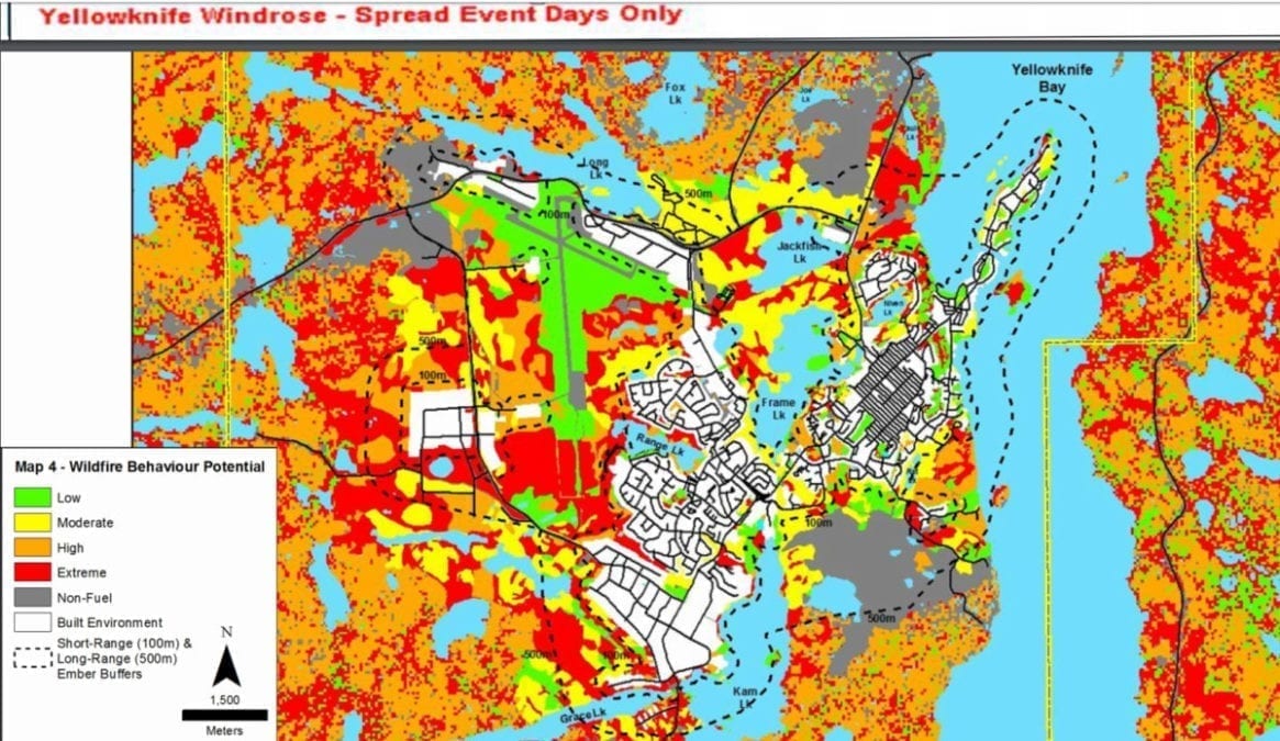
photo sourced from the Government Priorities Committee meeting of May 11, 2020
He noted that although undeveloped spaces with more dense spruce forest pose a greater risk to some buildings, such as north of Grace Lake residential development, the Yellowknife Airport serves as a sort of buffer to parts of the city.
New developments in areas like the Engle Business District also come with automatic mitigation of fire risk.
"As they develop property out there, they're blasting and they're clear-cutting so they're really doing the ultimate fire smart work by removing all the vegetation and just leaving non-combustible (material)," Bussey said. "So yeah, there's a lot of red out there (on the map), which is forest that can potentially carry on an extreme fire. But the good news is that as we develop that area more, we take out more of that spruce forest growth that causes the biggest concern."
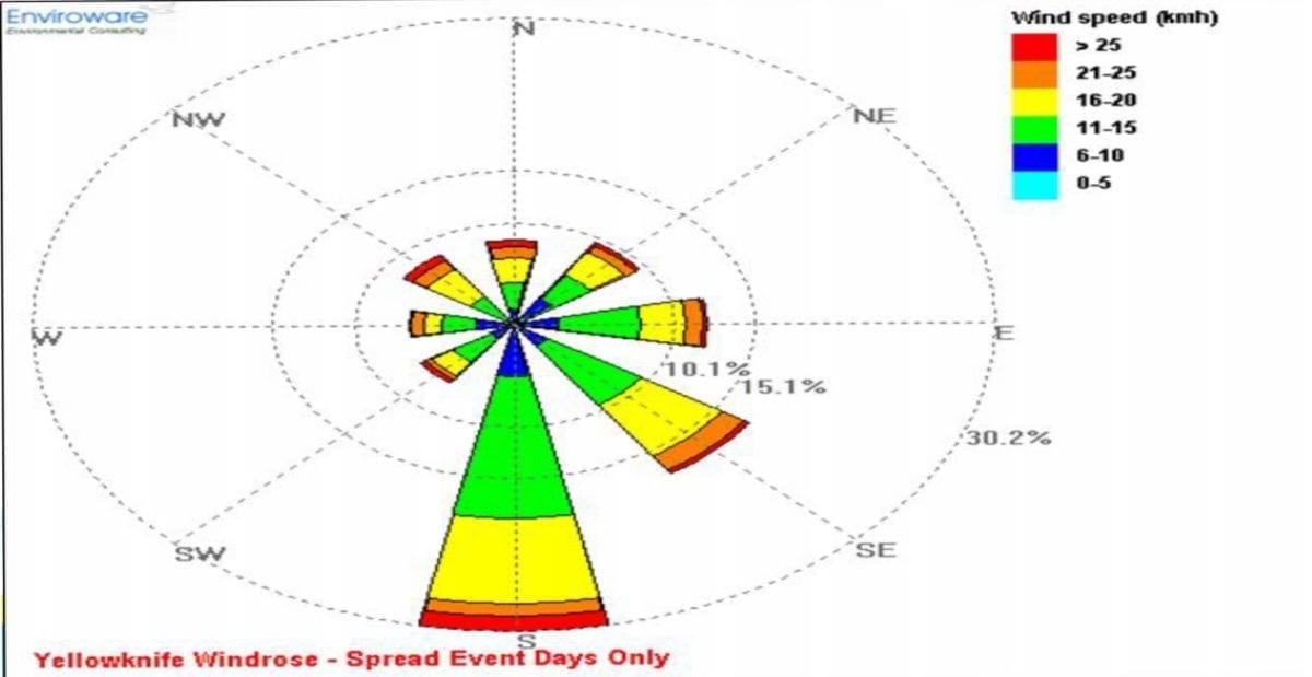
photo screenshot from the Government Priorities Committee Meeting
In other areas of the city, there are also "fairly extensive areas of non-fuel or low fuel areas" that don't present a high likelihood of spreading wildfire. Among those areas are the former Giant and Con mines to the north and east, as well as the sand pits to the northwest.
Bodies of water and wind direction
Bussey also pointed out that on top of the dead zones are benefits in the City of Yellowknife that include several bodies of water in and around the municipal boundaries like Yellowknife Bay and Back Bay, which generally inhibit fires from spreading. The prevailing wind direction on most days of the year when forest fire risk is high, proves to be positive, based on data accumulated by the city over 30 years.
"So the good news is that of those 35 (peak) days, which is average over a normal year, roughly half of those days the wind is coming from the south or southeast," he said. "That means those winds are coming over bodies of water, and that is good because the high-risk areas, as we have already mentioned, are on the west side of the city."