NWT residents can expect colder-than-average temperatures during the upcoming La Niña winter, Environment and Climate Change Canada forecasts.
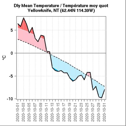
image sourced from Environment and Climate Change Canada
A La Niña winter takes place every few years. It's due to fluctuations in sea temperature between the ocean and atmosphere in the east-central equatorial Pacific Ocean, according to the National Oceanic and Atmospheric Administration (NOAA).
"Coming into a La Niña winter for Western Canada generally means that winters will be colder than average and snowier than average," said meteorologist Terri Lang. "Patterns are often much stronger for the Prairies and British Columbia and not as strong for the NWT, but people should be aware of colder-than-average (temperatures) with more snow than average and should definitely prepare."
September on the dry side
In September, the average temperature was fairly mild at 6.7 C, which was close to the 30-year average of 7.2 C. Precipitation for September amounted to 27.2 mm of rain. This compares to the average of 36.3 mm for that month based on a compilation of precipitation measurements over the last 75 years. September 2020 ended up being the 35th driest on record.
October
Lang said October temperatures began mild but dropped sharply by mid-month. Still, the monthly average of -1.8 C fit in with the historical trend. The monthly average for October based on 30 years of data is -1.7 C.
"It was warm in the first part and cold in the second part of the month, which (led to the) averaging out of the temperature," Lang said.
Over the course of October, there was 13.2 mm of precipitation from rain and some snowfall. The average amount of precipitation for that month is 30.3 mm. This made the month the 11th driest on record, based on 75 years worth of data, Lang said.
Yellowknife reported its first traces of snow flurries on Oct. 12, however, the first significant snowfall of 6 cm didn't occur until Oct. 31.
November
Colder temperatures continued into November with the coldest point coming on the morning of Remembrance Day when the temperature dropped to - 29.3 C, Lang said.
As of Nov. 12, Yellowknife had seen 9 cm of snow in total for the fall, she said.
A wet year
The typical annual precipitation level in Yellowknife is 288.6 mm, based on a 30-year average. The city is expected to surpass that figure by the end of the year as 267.1 mm has been recorded to date, Lang said.
Forest fire season
The Northwest Territories didn't experience a significant forest fire season this year largely because of substantial precipitation levels from last year, Lang said. That could happen again next year due to precipitation build-up from 2020, however, she said that fact is not always positive.
"We see it as good and bad because you have to remember that fire is a natural occurrence and it helps with moderating fires (so) there isn't a build-up of dry brush and that type of thing," she said. "If brush and deadwood build up in the forests, it can lead to greater risk for forest fires in the long run."